-
Home ›
-
Region Central Scotland ›
-
Stirling ›
-
Hotels in Stirling ›
-
Full Overview Stirling Court Hotel
- Further information >
-
-
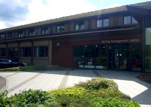
Stirling Court Hotel
University Of Stirling
Stirling
Stirling
Scotland
FK9 4LA United Kingdom.
General Hotel location
Outer City Centre Location - 2.3 miles from the Centre of Stirling
 Traveling By Car
 Traveling By Train
Check Prices and Times -, The Bridge of Allan Railway Station with a station code of BEA is approximately 1.3 miles away, direct line, point to point note: may be longer by road
Other Grid references:
Degrees minutes seconds (DMS)
56° 8' 57" North - 3° 55' 36" West
X (Easting) , Y (Northing)
280397,696841
Ordnance Survey Grid Reference , (also known as British National Grid (BNG)
NS 80397 96841
what3words ///
 = wires.politics.decoding = wires.politics.decoding
|