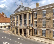
Stonehenge Inn to Stonehenge Driving Route
The driving route from Stonehenge Inn to Stonehenge covers approximately 6.2 miles, linking accommodation in Durrington with one of Britain’s most important prehistoric landmarks. From the inn, the journey heads through the local road network towards Amesbury and Salisbury Plain before following the signed approach to the Stonehenge visitor area. Travelling by car is the most practical option, particularly for guests carrying luggage or planning to continue exploring nearby attractions after their visit.
Stonehenge forms part of the UNESCO-listed Stonehenge, Avebury and Associated Sites World Heritage Site and is reached from the A303 via the local access roads serving the visitor centre. The interactive route map shows the road connection from the hotel to the attraction, helping visitors understand the direction of travel and the relative position of Durrington, Amesbury and Stonehenge. Journey times can vary with traffic, especially during weekends, school holidays and other busy visitor periods.
Stonehenge forms part of the UNESCO-listed Stonehenge, Avebury and Associated Sites World Heritage Site and is reached from the A303 via the local access roads serving the visitor centre. The interactive route map shows the road connection from the hotel to the attraction, helping visitors understand the direction of travel and the relative position of Durrington, Amesbury and Stonehenge. Journey times can vary with traffic, especially during weekends, school holidays and other busy visitor periods.
Driving route
Walking route
Destination: Stonehenge
Selected hotel
Place to see
Plan Your Stay
View hotel details, facilities and booking information for Stonehenge Inn.
We may earn a small commission at no extra cost to you, which helps fund our website and the unique content we provide.Visitor information
Opening hours: Summer - 9:30 am – 7:00 pm<br> Winter (October – March): 9:30 am – 5:00 pm Closed Christmas day