

- Hotel Finder UK ›
- Region Northern Ireland ›
- County Down ›
- Rathfriland ›
- Kiltariff Hall Country House ›
- Further information >
- maps & directions -
- Local Attractions -
Kiltariff Hall Country House
5 Drumlough Road
Rathfriland
County Down
Northern Ireland
BT34 5DN
United Kingdom
This property is at an elevation of approximately 326 feet / 99.4 metres above sea level
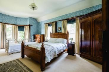
Facilities at the accommodation
Ensuite or Private Bathroom
Shower or Bath
Tea / Coffee making facilities
Breakfast available
Special Diet Options
Car Parking onsite / close by
TV in Room
Digital TV Channels
Open All Year
Free Wifi Internet
Garden
Laundry Services
 Mourne Mountains views

Ensuite or Private Bathroom
Shower or Bath
Tea / Coffee making facilities
Breakfast available
Special Diet Options
Car Parking onsite / close by
TV in Room
Digital TV Channels
Open All Year
Free Wifi Internet
Garden
Laundry Services
Facilities Nearby
Entertainment
Bar / Pub
Restaurant/s
Fishing
Entertainment
Bar / Pub
Restaurant/s
Fishing
Hotel Travel & Directions Hub
Newtownards County Down
BT23 8SG
31.2 miles Isle of Man Airport
Malew Isle of Man
IM9 2AS
62.9 miles
17.6 miles M1 (NI) Junction 9
Moira, Antrim A26 International Airport
17.7 miles M12 (NI) Junction 2
Craigavon centre, Portadown, Armagh
18.1 miles
station code =
BT35 6JW
8.3 miles Poyntzpass
station code =
BT35 6UF
9.1 miles
Hotels near Kiltariff Hall Country House Bed and breakfast Rathfriland


Banbridge Golf Club -
BT32 3UR
 NW 21922 04567
 = inherit.rewriting.rucksack Hotels nearby.
9.9m / 15.9km
= inherit.rewriting.rucksack Hotels nearby.
9.9m / 15.9km
BT32 3UR

Slieve Bearnagh -
BT34 4RQ
= watchdogs.asking.trams Hotels nearby.
 Elevation = 739 Meters / 2424.5 Feet
8.1m / 13km -
BT34 4RQ
8.1m / 13km -
Slieve Binnian -
BT34 4XH
= immune.flopped.chop Hotels nearby.
Elevation = 747 Meters / 2450.8 Feet
9.9m / 15.9km
BT34 4XH
9.9m / 15.9km

National Trust - Derrymore House -
BT35 7EF
SB 14118 85996
= blossom.mastering.impulses Hotels nearby.
9.1m / 14.6km -
BT35 7EF

Warrenpoint Pier -
BT34 3NQ
SB 21985 75152
= held.snuggled.sunroof Hotels nearby.
BT34 3NQ
Local fishing pier
10m / 16.1km

Slieve Donard - Sliabh Donairt -
J358276
= curated.readings.backtrack Hotels nearby.
Elevation = 850 Meters / 2788.7 Feet
10.7m / 17.2km
Slieve Donard is a mountain located in County Down, Northern Ireland. It is the highest peak in Northern Ireland, with a summit elevation of 850 meters (2,790 feet).
10.7m / 17.2km
 View further
 View more hotels nearby with distances
Leigh House Bed and Breakfast - Ballyroney - 1.84
Clonmurr B&B - Ballyroney - 3.32
The View at 37 B&B - Banbridge - 5.72
Mourne Country Hotel - Newry - 7.23
Clanrye House B&B - Newry - 7.33
Canal Court Hotel - Newry - 7.91
Belmont House Hotel - Banbridge - 8.65
Highfields B&B - Newry - 8.67
Woodview Bed & Breakfast - Kilkeel - 8.98
The Rostrevor Inn - Rostrevor - 9.22
Nearby Cities, towns and local villages near Rathfriland
Main Towns
Small Towns
Villages or districts